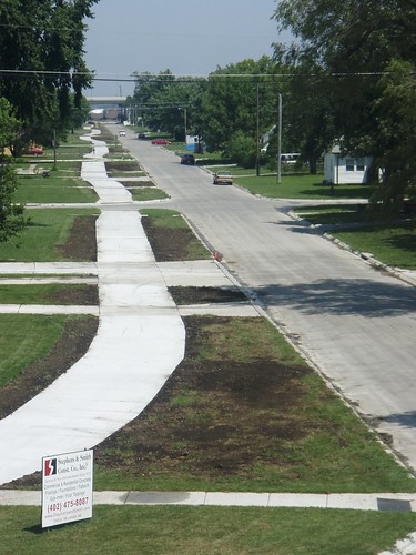
A Bike Path Failure
By: Mr. Wilson on
July 21, 2008
 That is one screwed up trail. It's very unfriendly to bikes in two ways. The first is its crookedness. You could get seasick on that thing. More importantly, it crosses many streets and driveways. Crosswalks and driveway crossings are very dangerous for bicyclists. Not to mention the problem of cars parked in driveways blocking all or part of the trail.
Others have already noted that this portion of the path probably should have been on-street, either with or without a marked bike lane. There's nothing wrong with an on-street bike path, especially in a neighborhood like the one shown.
What do you think? Have you used the trail?
Comments
See what your friends and neighbors have to say about this.
My dog Fuggles loves it. I was doing laps on the first block they poured.
Even if it is messed up, I am really glad it is on my block and will eventually end in Marysville KS.
Now they need to finish the section between A street and Calvert. Hurry up guys 😉
That just looks kind of screwy-how is it a ‘bike path/MUP’ if it crosses every driveway? Kind of like a sidewalk…..that we aren’t supposed to ride on. Granted, it does look sleepy, so the street is probably fine, but jeez….
it looks perfectly normal to me. 😉
Where is this anyway? And why did they cut through all those lawns?
If you happen to ride a skinny wheeled road bike, like me, and decide to take the Jamaica trail north into town from Saltillo, be aware that there is a 30 or so foot hole in the middle of the trail just before Old Cheney. Problem is though, you’re not told until you’re 100 yards or so from where the trail is closed. You’re directed to just cut through mosquito and mud-infested Wilderness park on your skinny wheeled bike…
Hint to parks and recreation: put a sign at 14th St. that the trail does not go through, unless you want to risk West Nile Virus.
4th street between A & J
Once there were train tracks with gravel roads on each side. Last year when they poured the street the lawns got chewed up big time and reseeded with some sort of sprayed on grass stuff. Most folk gained a bunch of lawn. The spray grew really well this spring from all the rain.
Right before the trail was poured they went and mowed the whole side of the block and then started doing the trail. There was not much marking of the trail beforehand. A few stakes here and there.
I has theory
I think the final plan is for a trail to connect to the J street end leading to campus. The northern end of the trail is heavier traffic wise so the sweeping line keeps speed down.
It would be lame for the trail to just stop between A&J;so they needed to pour a sidewalk anyways after the street reconstruction. Might as well make it a wide path.
Just a guess, but the logic seems legit.
Share your thoughts with the community.
Commenting is no longer permitted on this post.